Current Situation
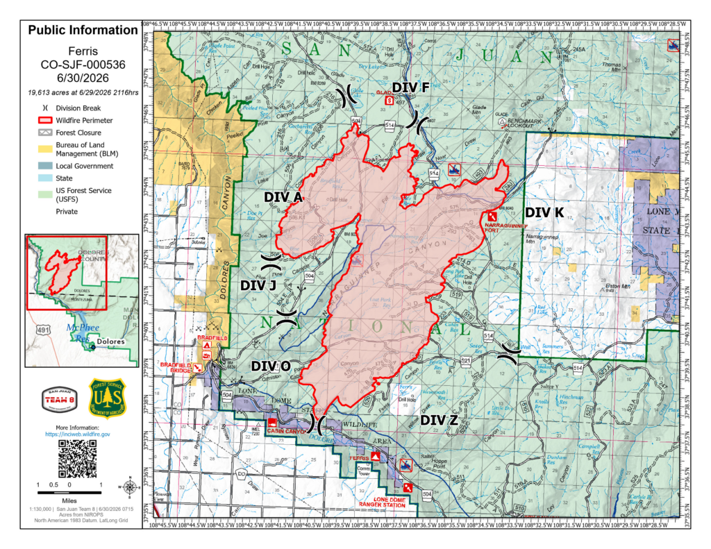
Wind and fire behavior moderated slightly yesterday, allowing crews to build fireline directly on portions of the active fire edge to protect homes and private land. The fire showed little growth in the northeast, the area closest to evacuated homes.
Crews completed a burnout operation overnight to remove unburned fuels between the fire and National Forest Service Road (NFSR) 240, creating a containment line to help protect the Glade Ranch Subdivision.
The fire has not reached private lands or the Benchmark Lookout Tower. Firefighters also prepared the Glade Guard Station to improve protection if the fire advances north.
Red Flag conditions are expected today, with ridge-top wind gusts reaching 45–50 mph. Helicopters supported firefighters with water drops yesterday and are expected to fly again today, although increasing winds could limit aerial operations later in the day.
The Ferris Fire is burning approximately 15 miles northwest of Dolores, Colorado. The fire was started by lightning and is burning on the Dolores Ranger District of the San Juan National Forest. It is being managed by San Juan Team 8, a local Type 3 Incident Management Team.
Operations
- Division K (East/North):
Firefighters continue structure assessments and structure protection on private lands and nearby infrastructure. A hotshot crew is constructing direct fireline where conditions allow, tying into existing roads with helicopter water-drop support. Active fire behavior on the northeast flank continues to challenge crews. - Division A (West Side):
Bulldozers and hand crews continue constructing fireline toward Doe Canyon after making good progress yesterday. - Division Z (Heel of the Fire):
Crews completed burnout operations along National Forest Service Road 520 around 4:00 a.m., tying the fire into the roadway to better protect nearby private property. Today’s objective is to keep the fire west of NFSR 520.
Resources
Resources assigned include engines, hand crews, air attack, three heavy helicopters, one light helicopter, and Large Air Tankers (LATs) when needed. Additional crews and support personnel remain on order.
Evacuations and Closures
- Dolores County has issued evacuation orders for Glade Ranch residents.
- A pre-evacuation notice remains in effect for areas farther east.
- Montezuma County has issued evacuations for private lands along the lower Dolores River corridor from the dam to Bradfield Bridge.
- The San Juan National Forest has implemented a Fire Area Closure.
Flight Restrictions
Private aircraft, including drones, are prohibited from flying over the fire area. A Temporary Flight Restriction (TFR) remains in effect.
Smoke Information
For current air quality information, visit the Colorado Department of Public Health and Environment smoke resources.
Stay Informed
For official updates, follow the Ferris Fire Information Facebook page or the Ferris Fire InciWeb page.
To receive future daily updates, sign up through the official notification system.